Thursday 30 July 2015


Day 109 - 30th July

Yambuk to Carpenter Rocks

Distance Travelled - 324.1 km

Had a fairly disrupted night waking up at 1am after going to bed at about 9.30pm. Couldn't get back to sleep for ages, eventually falling asleep sometime after 2.30 am. Woke another couple of times between then and 7 am when I finally got out of bed. Went for a wander and saw a magnificent sunrise creep out from under a cloud ridden sky.

Had breakfast and set off towards Portland. Just before I pulled up last night the fuel light came on and the car computer indicated that there was still 150 km of fuel left. As I travelled the first 25 km the computer readout dropped to 110 km. I stopped on the side of the road to take a quick photo of a fence full of shoes and when I returned to the car the engine was off. The engine wouldn't start even though it was turning over. Tried a second time and it came to life coughing and spluttering and then settled. As I drove along the next 5 km or so the car kept surging and losing power. Concerned that I was going to completely run out of fuel I pulled over, put on the hazard lights and popped the bonnet. I had just popped the bonnet when a guy pulled up behind me to see if he could help. He took me into Portland with my jerry can so I could get fuel. He was most apologetic that he had an appointment he had to keep otherwise he would have taken me straight back out.

As I finished filling up the container a guy came into the service station and was fuelling up when I asked him if he was heading towards Yambuk. He replied no but asked why. After explaining my predicament he said he was happy to take me back to the car anyway. I said not to worry as he wasn't going that way but he was adamant that he would do it. He dropped me off and left on his way, smiling and waving as he went. Emptied the fuel into the car and tried starting it with no luck, managing only to flatten the battery after two attempts at starting. Got out the jumper leads and started trying to get someone to stop and help me. It was very overcast and threatening to rain which ruled out the possibility of using the solar panels.  

I was surprised to see a woman stop but did not want to worry her so I said I was uncomfortable using a new car to jump start mine but thanked for being prepared to stop. A minute after she left a guy in an old Telstra ute stopped. We decided we needed to prime the fuel and worked out how to do that and then set up the jumper leads and fairly soon got the car going. About 2 minutes after he left the rain came down and stayed with me for the next few hours.

Drove through to Portland and dodged the rain to take photos of the 2 lighthouses close to the town, Whalers Bluff lighthouse and Cape Nelson. Grabbed some lunch and posted the blog at the local library before heading off towards Mt Gambier in SA.

Drove through with strong winds and persistent light rain. Went to the visitor centre and got some info about lighthouse locations from a very helpful lady and then went off in search of them. Passed a fire station on the way so decided to call in and see if I could get a quick squiz at the station. 1.5 hours later I got away having had a really interesting talk with the station officer and a very in-depth tour of the station. Came out of the station to rain absolutely pelting down and wind whipping through, most unhappy tenting weather.

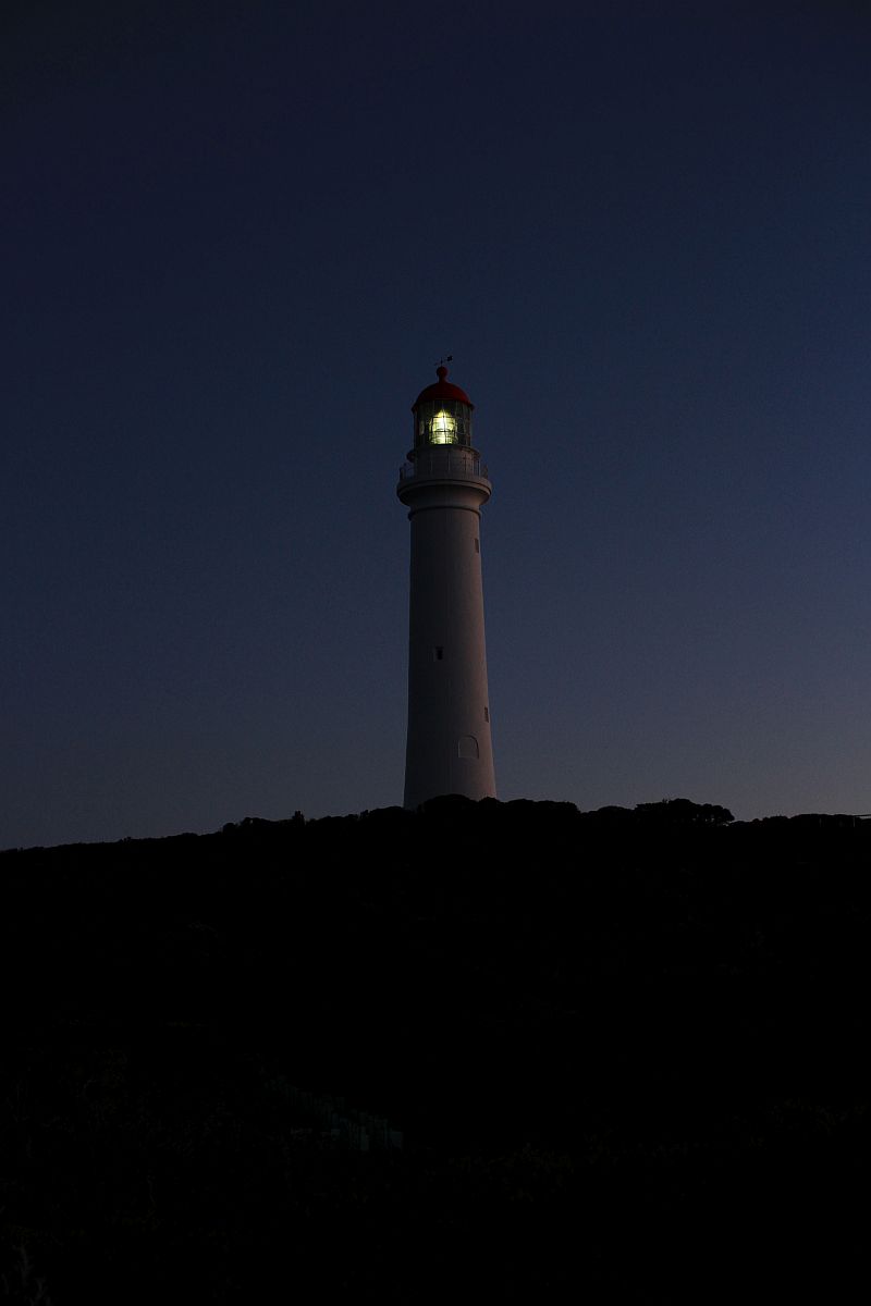
Headed out to the Cape Northumberland lighthouse and pulled up, sitting in the car for a while waiting for the rain to ease. Should have gone out sooner because just as I was getting out another car came in. The guy got out and asked what I was doing there. I explained what I was doing and asked if it was okay to take a photo of the lighthouse as there was a chain across the short road leading to the lighthouse. I was told in no uncertain terms to get lost and no I could NOT take photos of the lighthouse, it is on private property. He reiterated my need to leave and turned and walked off toward the nearby house, an old keepers cottage. I turned and took a quick snap of the lighthouse from where I was just to spite him, even though it was not the best of shots. I don't mind being told I can't access places but there is no need for that level of rudeness or hostility.

Left there and headed to Carpenter Rocks and the Cape Banks lighthouse. Dodged the rain and got a few shots before finding a place nearby to camp the night. There is a shelter that should offer adequate cover but I will wait until nearly bed time before setting up to see what happens with the weather and decide then whether to sleep in the car or tent tonight.

Tomorrow I will head towards the next set of lighthouses, starting with Cape Martin at Beachport, then Robe and then possibly Kingston Foreshore, Cape Jaffa and Point Malcolm. I doubt I will get all of them done tomorrow but who knows. Saturday I will head towards Adelaide I am guessing and then it will be the beginning of the final leg back to Southern Cross.    
 
                                                                        Yambuk sunrise

                                                                     Yambuk sunrise
 
                                                            Whaler's Bluff lighthouse

                                                              Cape Nelson lighthouse

Cape Northumberland lighthouse (stolen photo)
 
                                                               Cape Banks lighthouse


Wednesday 29 July 2015

Day 108 - 29th July

Princetown to Yambuk

Distance Travelled - 211.4 km

After a dry night under cover whilst it was raining in the open I woke up about 6.30 am and stayed in bed until about 7 am. Got up and had breakfast and then took advantage of the power at the campsite to do some computing and file sorting with my photos. I packed everything away except the tent to let it dry out from condensation as much as possible before leaving. Went for a walk around the nearby oval while I waited for the tent to dry a bit.

After leaving the campsite it wasn't far to the the first stop which was at the 12 Apostles. These were something to behold, not just because of the majesty they seemed to exude, but also observing the awesome power and strength of the surf pounding in and smashing up against the limestone pillars. Stood for quite a while just watching the scene as it seemed to be on constant rewind and play, never seeming to get boring.

Leaving the 12 Apostles I headed on towards Port Campbell visiting the Loch and Gorge where there is spectacular scenery and the tale of a shipwreck on the cliff there. The nearby cemetery is the final resting place of 4 passengers of the ship, all the crew died except one and he managed to save one passenger.

After dragging myself away from here I went through to Port Campbell, visiting the Info Centre and posting my blog before heading on to the Arch, London Bridge and the Grotto - all sandstone formations in the coast and all looking very impressive. There were a few other stops along the way looking at coves and other formations before getting to Peterborough. Stopped there for a few minutes for a stretch and then continued on to Warrnambool.

At Warrnambool I went to the Flagstaff Hill Maritime Village and saw the Lady Bay upper and lower lighthouses. Called in to the CFA complex and had a chat and a coffee with some of the firey's there which was nice. It has been very pleasing to have been so readily welcomed by all the different firey's I have come across on my trip so far.

After Warrnambool I continued on to Port Fairy and saw the lighthouse there which looked interesting with the white tower in stark contrast to the black rocks around the base in the water. After finishing there I headed on towards Portland, looking for a place to stop for the night. Found one that looked suitable at Yambuk with a shelter that should give me protection from the forecast possible rain tonight.


Tomorrow I head for Portland and the 2 lighthouses near there and then on towards Mount Gambier in South Australia and the lighthouses I haven't photographed along that section of the SA coast yet. 


                                                               Part of the 12 Apostles

                                 Bay where the survivors of the shipwreck Loch Ard washed up

                                                           London Bridge formation

                                                                       The Arch

                                                                        The Grotto

                                                            Lady Bay lower lighthouse

                                                            Lady Bay upper lighthouse

                                                                Port Fairy Lighthouse

Tuesday 28 July 2015

Day 106  - 27th July

Point Lonsdale to Airey's Inlet

Distance Travelled - 89 km

Had a reasonably good sleep last night all things considered. Woke up once during the night to heavyish sounding rain and closed the windows and then woke again about 5.30 am and opened the windows to minimise condensation build up. Eventually got up at about 7 am and walked down to the beach near the lighthouse to take some photos. The water was still quite high which restricted options but got a few shots and then went back to the car and drove over to Queenscliffe.

Had breakfast in the car park near the White lighthouse and then set off to take some more photos of that one. Got  a few done and sat back in the car and read for a while and then decided to drive into town. Parked outside the Info Centre and went for a walk along the streets looking at various shops and walked up to where the Fort is that houses the Black lighthouse. The gates were open so I went in and spoke to the guard who informed me that there was a tour on today and that would be the only way of getting access to the lighthouse. The tour begins at 1 pm so I had 4 hours to kill before then.

Walked back to the car stopping at a few antique and op shops and book shops and galleries and then drove back to the White lighthouse for more photos. Chatted to a guy cleaning the small monuments and plaques there and he was a great source of info about the ocean and lighthouses. There is a huge rip in the ocean here that makes it one of the most dangerous bays in the world as far as shipping is concerned. A pilot service operates where specially trained sailors go out and meet the big container ships, naval ships, passenger ships etc and they pilot them through this section and into the bay further. Apparently they charge about $3000 per trip and everyone has to use it. The only people who don't are the Tasmanian ferry operators who do the trip so often they are trained and experienced at it.

After chatting to this guy for quite a while I headed back to the Fort and waited there for 20 minutes reading my book until the tour was ready to start. The lady who took the tour was very thorough and talked not only about the Fort and the various roles it has performed over the years but also discussed a lot of things pertinent to the town that could be seen from the Fort. She talked briefly about the lighthouse as well. I managed to take a few shots of the lighthouse during the tour and decided afterwards that it had been worth the $10 entry fee.

The tour finished at about 2.30 pm and I headed off then to begin the Great Ocean Road drive towards the next set of lighthouses. The drive was quite pleasant and I go to Airey's Inlet where the Split Point Lighthouse is located. Took a series of photos of the lighthouse from different positions  around the area as well as some of the rock formation nearby. The rock is a smaller version of the pillars or Apostles further down the Great Ocean Road that has been carved off the main land by erosion from the sea.

After finishing with the photos I went wandering around town and then went back to the car and off in search of a place to sleep the night. Found a spot that should be suitable that is not far from the lighthouse. Had tea after reading for a while and then wrote the blog and sorted photos and poured over maps for a while vaguely panning out the next few days. After finishing this it will be music for a while then I will set up the tent and get ready for bed. There will possibly be some early morning photography tomorrow if I wake up in time. If not then after packing I will start heading towards Cape Otway and the lighthouse there.

                                                        Point Lonsdale Lighthouse

                                                       Point Lonsdale Lighthouse

                                                       Queenscliffe White Lighthouse

                                                    Queenscliffe White Lighthouse

                                                       Queenscliffe Black Lighthouse

                                                    Queenscliffe Black Lighthouse

                                           Seagull at Queenscliffe

                                                       Split Point Lighthouse, night shot

                                               Split Point Lighthouse and keepers cottage


Day 107 - 28th July

Aireys Inlet to Princetown

Distance Travelled - 206.6 km

Breaking news! Breaking being the operative word. Went out last night to do some night photography of the lighthouse and somehow my camera manged to fall off the tripod and land lens down on the ground, cracking the filter and making the focus part inoperable at the moment. I will have a little play with it later and see if I can get it working again but I am not hopeful. I can still use it on the one setting it was one when it dropped and it seems to still zoom in and out so it is not completely cactus and may still be useful for some night shots. It does mean that I am now relying on my 30mm lens as my widest lens and given the location of lighthouses it has not always been possible in the past to fit them all in one shot using that lens, but I will try and view it as a challenge and see what I can achieve. I will be travelling back this way in October when I go to Tassie so if I can't get some shots now then there is always the possibility of doing them when I come across later.

Heard rain a few times during the night and was glad to be under cover. Got up about 6 am, packed away and headed back to the lighthouse to see if sunrise might provide a nice backdrop. Unfortunately the sun did not want to play nicely today. Took a few photos using the 30 mm lens and then headed to the beach to take some photos of Eagle Rock. Walked down the steps to see if it was worth getting shots of and then had to come back up, get the camera and go back down again. By the time I got up again and walked up about 250 steps. Went back to the spot I camped in to have breakfast and a coffee. Read for a while as I pondered how to attack the lens and see if I can get it going again. Came up with nothing feasible and in the process only took in about half of what i read.

Before heading off I went and looked at a few galleries and shops but there was not much of interest to me. Drove through to Lorne, enjoying the vista of the ocean as the road wound round bend after bend, a very enjoyable drive. Got out at Lorne and went for walk along the main drag and then went to the Info Centre. Chatted there for a while and tried to post the blog but had difficulty logging on so left it do do at the next spot.

Left the Info Centre and went out to Erskine Falls, a very beautiful waterfall about 10 minutes inland from Lorne. It still amazes me that I can be right on the beach and within a few minutes drive be surrounded by rain forest. Took some photos of the falls and then walked along the track for a bit before returning up to car via about 160 steps.

Drove from Lorne to Apollo Bay went to the Info Centre there only to have the same issue with the Internet. Left the centre and had some lunch before going for a walk through the town looking at a couple of book shops and op shops which ended up having nothing I wanted.

Drove to a place called Mait's Rest which is a nice walk through the rain forest between Apollo Bay and Cape Otway. It was really lush with huge 100 m tall trees and massive 10 foot ferns. I really enjoyed the wander through there, taking a few photos as I went. Left there and continued on to Cape Otway and the next lighthouse.

This is another fee paying lighthouse and I thought the $19.50 entrance fee was a tad high and mentioned this and was told that there really was nothing to be done about it. I succumbed and went and got some money and decided to buy a couple of small souvenirs as well. Souvenirs cost $8.90 and I was charge $16.40 in total. The guy behind the counter winked at me and said I was getting photographer's rates so as to not cause issues with other people nearby waiting to enter. Yay, a little win for me!

The lighthouse is quite historic as it was the first one built in Australia in 1848. Photographically speaking it is not anything special and is no longer operational so that answered my wonderings as to how to get a night shot of it. It meant I was able to leave the Cape Otway area earlier than expected. When I come back on the way to Tassie I will do the Otway Tree Top Tour but apparently you have to book beforehand and usually allow 3 hours from booking to getting in. With extremely regular rain today I did not feel like sitting around waiting for that so will do it later.

Left the Lighthouse and continued on towards Port Campbell. Stopped at Princetown for the night which is just before the 12 Apostles and other stone features famous along the Great Ocean Road. I will look at them tomorrow morning on the way out of here and on my way to the next lighthouse at  Warrnambool.
                                                    Split Point Lighthouse, early morning

                                                 Eagle Rock near Split Point Lighthouse

                                                                      Erskine Falls

                                                         Large tree on Mait's Rest walk

                                                          Cape Otway Lighthouse

Sunday 26 July 2015

Day 105 - 26th July

Southbank to Point Lonsdale

Distance Travelled - 128.7 km

Woke up at about 6 am, remarkably refreshed and with a back feeling much less sore than usual after a night sleeping on the floor at Lindsay and Heather's. Stayed under the sleeping back and tried to go back to sleep without success until about 7.30 am when I finally ventured out. Heather and Lindsay were already awake and I was provided with a welcome coffee before heading off on a walk around town for about 40 minutes.

Came back and chatted with Lindsay and Heather for a while about a variety of things before heading off on another walk though the Crown complex, looking at the dazzling array of lights and waterfall in the foyer and reception area. It all looked very opulent and flash. Continued on out the back exit and wandered down to the Polly Woodside Maritime Museum where the Gellibrand Pile Light was housed. This lighthouse was partially destroyed some time ago when a ship ran into it. It was removed and at some stage went into the museum. Having got there I talked to people  there to find that it has been removed when building works were going on around the museum as they considered it too risky to leave there in case it got damaged further. The lady there gave me an address where it is currently being stored but apparently it is not much to look at as the stand and surrounds are missing and it is just the top part of the light.

Talking to Lindsay when I got back it would appear that Skipton where the light is being stored s significantly off the track for my proposed route and so not really worth the detour to see it. It is also housed in a National Trust storage building and there is no guarantee that even if I got there I would be able to access it.

After chatting some more I took the last of my stuff to the car and left at about noon and headed off to Willimmstown, the location of the next lighthouse. This lighthouse is not working as a lighthouse anymore but the original stone tower is still there and looks quite impressive. Took a few photos and wandered through the nearby information centre for a while before continuing on my way to Point Lonsdale, past Geelong.

The weather on the way down was very windy and I encountered some quite heavy rain at times. Finally got to Queenscliffe where 2 of the 3 lighthouses are located. The first I found was the Queenscliffe White lighthouse. This is on the very edge of the land overlooking the beach and has a large metal lattice tower on each side of it, making it somewhat difficult to get a decent photo of it.

Went and found the Queenscliffe Black lighthouse which is located within the grounds of Fort Lonsdale and not accessible except on a tour of the Fort. Tours run Saturday and Sunday at 1 pm and 3 pm. The tine was now 3.30 pm and I had missed my chance to see it. Went off and visited the Information Centre to see if there was any other way to view the lighthouse. Whilst the guy at the Info Centre was very happy to chat there was no other ways he knew of accessing the lighthouse. He gave me a pamphlet about the Fort and there is a contact number on the back. I will ring it tomorrow and see if something can be organised so I can get in a take a few photos.

After leaving the info centre I went back to the Fort where I could park by the beach and I saw the gates to the Fort were open. I walked over to see if I could source a way of getting in only to be confronted by a security guard about to lock the gates. I explained my dilemma to him and asked if he could take me in for 5 minutes to take a couple of photos but he would not. So I am back to plan B, ringing tomorrow and trying to sort something.

I went down to the beach and looked around there for a bit, took a couple of photos and then decided it was time for tea. Splashed out and bought fish and chips for tea and ate them down at the beach near the White lighthouse. After tea I dove about 6 km to Lonsdale where the other lighthouse is. Once again it is not particularly well located for photography but viewing it in daylight might provide answers. I went for a walk along the jetty and then came back to the car, made some phone calls and then started writing the blog. I have decided to sleep in the car tonight as there is not really any suitable options for camping here.

Tomorrow I will do some more photography of the lighthouses and then move on towards Airly and the Split Point Lighthouse and the beginning of the Great Ocean Road drive that I am very much looking forward to. After the disappointment of today's lighthouses that I thought would be much grander than they turned out to be I hope the Great Ocean Road is everything I have heard it to be.

                                                            Williamstown Lighthouse

                                                            Williamstown Lighthouse

                                                        Queenscliffe White Lighthouse

                                                         Queenscliffe White Lighthouse

                                            New laser navigational tower at Queenscliffe


Saturday 25 July 2015

Day 104 - 25th July

Macrae to Melbourne (Southbank)

Distance Travelled - 110 km

Woke up at about 6 am to a surprisingly dry car interior. Leaving the windows down a fraction managed to stop too much condensation building up overnight. Read for a little while and listened to some music whilst finishing waking up properly. Got up and and spent some time reorganising the car and then went for a walk along the beach and boardwalk for about 40 mins, stretching the legs out after sleeping in somewhat weird positions during the night.

Came back from the walk and and had breakfast before heading down to Maccas to post the blog. After finishing that I went for a wander through town and looked at a couple of shops before finally leaving for the city at about 10 am.

Drove through to Melbourne and found Lindsay and Heather's place without too much difficulty. Lindsay came down and showed me where to park and then we went up to their apartment and spent time chatting and catching up. Had a very nice soup for lunch and chatted some more before I headed off to visit a local fire station and go to Port Melbourne to see the lighthouses there.

I was thoroughly welcomed at the fire station and given the grand tour of the station, going through the appliances and rooms, very wide-eyed at some of the equipment they have on their appliances. In particular, the wide range of detectors they have for chemical and explosive warfare particulates they have in response to the growing threat of terrorism was of interest to see.

After leaving the station I went down to Port Melbourne which is only about 3 km from where Lindsay and Heather live. There are 2 lighthouses there, one in the water and another further back about a block or so into the suburb. The read light is significantly taller than the front one. The idea is that ships would line up the two lights and follow that path which would lead them through / along the designated channel into the port. Took a couple of photos of the lighthouses and then walked along the boardwalk for a bit before coming back to Princes Pier where I spent some time taking photos of the old pylons at the end of the pier. There were 5 or 6 other people there taking photos as well.

Left the pier and went back to the apartment where we had tea and chatted before Nathan (Heather's son) turned up with his daughter Rebecca who was going to be staying the night with them. We continued to chat for a while and then watched the movie Labrynth whilst I was doing computer work before retiring to bed.

Tomorrow I will head off at some stage towards Williamstown, not very far from here, and take photos of the lighthouse there before heading down towards Lonsdale. It has been great catching up with Lindsay and Heather and hopefully I will do it again when I come back later in the year to catch the ferry to Tassie.

                                             Bonus lighthouse on the way into the city,
                                              situated at Lighthouse Christian College

                                                           Port Melbourne front light

                                                          Port Melbourne front light

                                                           Port Melbourne rear light

                                                    Starfish on old pylon at Princes Pier

Friday 24 July 2015

Day 103 -24th July

Pakenham to Macrae (via Rosedale)

Distance Travelled - 425.6 km

Woke up at about 5 am to the sound of rain and was very thankful to be inside. Didn't really get back to sleep properly but tossed and turned and had little dozes until 7 am when I got out of bed. Had a shower and got ready, ate breakfast and packed away before almost pulling the car apart looking for the thumb drive. Could not find it so packed away and drove off to Maccas to post the blog, and search the net for a number for the Rosedale Neighbourhood House where I thought I had left the drive.

They open at 9 am so rang at 5 to and only got the day care that runs out of the centre. The girl on the phone was very helpful and went and checked the computer but replied that nothing was there. I thanked her and said  I would ring back later when someone might be in the office.

Fifteen minutes later I rang back only to get the same girl, no one had come to the office yet. She went into the office but could not see anything resembling the thumb drive so she said she would write down my number and as soon as someone came in to the office she would get them to call me. As she picked up the post it notes to write my number on she found the drive under the notes. I thanked her and said I would be there in a while to pick it up.

The 130 km drive took just over an hour and a half with 6 different sets of roadworks to drive through so it was nearly 11 am when I got there. The lady in the office was very chatty so it was 11.30 am before I got away. Typing in the address for my next stop into the GPS showed me I was going to drive basically right passed where I stayed last night and hten travel about another 70 km to the lighthouse.

Set off with a little teeth grinding at the wasted tome and fuel in getting the drive but that will teach me to leave things behind. Drove out to the lighthouse, grabbing some lunch on the way and got there about 2.30 pm. Was disappointed to find that the lighthouse is located on privately leased land and there is a fee for going to look at it. I took some photos from out on the rocks but the sun was in exactly the wrong position so in the end went back and talked to the lady at the kiosk who does the tours etc. I told her I was not interested in looking in the museum or inside the lighthouse or in a tour and all that I really wanted to do was take a few photos of the lighthouse. I explained my trip etc and she said the best she could do was to charge me $10 to go in instead of the usual $14 for entry to the grounds and museum or $17.50 for that plus the lighthouse tour. I begrudgingly agreed and went through. There would be no sneaking in later, it is fenced off with looked turnstiles and gates to go through to enter the reserve.

Spent 15 or 20 minutes wandering around looking at the lighthouse and taking some photos before leaving to try and get to the Eastern Lighthouse at Macrae and maybe into Melbourne to see (Uncle) Lindsay and Heather. Plugged the address into the GPS and went somewhere close, but completely different. it took me to the ferry terminal that travels from there to Queenscliffe. I entered some less specific info into the GPS and off I went again, this time  to the right place.

By this time it was getting dark and looking rather stormy. I rang Lindsay and organised to meet with them tomorrow and then hunted for somewhere here to stay. I did not much feel like driving into Melbourne in the dark and with potentially stormy weather. Options here were very limited so decided to sleep in the car at a local rest area near the beach. Ate tea and decided to write the blog and sort photos while it is raining a bit. If it clears at all I might go for a wander and see if the light is operational at night, I don't think it is though. After that it will be reading and music until the sleep fairy comes to take me to slumberland. Tomorrow I head into Melbourne to meet Lindsay and Heather for lunch and then make plans from there.

                                                        The bay at Cape Schank

                                                   Cape Schank Lighthouse compound

                                                        Cape Schank Lighthouse

                                                         Eastern Lighthouse at Macrae

Thursday 23 July 2015

Day 102 - 23rd July

Rosedale to Pakenham via Cape Liptrap

Distance Travelled - 309.3 km

As I sit and write today's blog I think I have left my thumb drive back in Rosedale in the computer at the community centre where I posted the blog yesterday. I will have to ring them in the morning and if it is there go back and get it. From here it is about 128 km to get there. That sucks!

Woke up this morning and was glad that I had been under cover as everything around was covered in dew. The tent reeks of campfire smoke where the wind blew smoke through the tent last night but I would rather that than be wet. Got up and went for a walk into town while I waited for others to maybe rise so as not to disturb them too much with packing away noises. Got back and saw movement at the other sites so packed away and had breakfast. Read for a little while until it was nearly 9 o'clock and then drove around to the other side of town where the community centre is.
Went in and accessed the computers and after posting the blog, reading and replying to emails and doing a little research I was on my way to Cape Liptrap.

The drive out to Cape Liptrap was predominantly through dairy country with lush green hills, cattle wandering through the paddocks or lounging on the grass and semi regular cheese factories.Stopped in and wandered through a few of the towns on the way and ended up out at the lighthouse by just before lunchtime. Spent some time at the lighthouse looking out over the coast and then headed of to Walkerville, just up the road from the lighthouse (about 15 km point to point) to the site of some old lime kilns. They were right on the beach and looked quite impressive, leftovers from the lime burning days of old.

Leaving the kilns, it was time to try and find somewhere to camp for the night. The closer I get to Melbourne city the fewer the options for free camping or roadside stops. Poring over the map book I saw the location of Pakenham nad remembered they had sent a juniors team to the Fire Brigade Championships in Perth on a few occasions. Decided to go there and see if I could score an undercover veranda for the night.

Got there and was warmly welcomed. I was given the use of the old fire station in town for the night which meant being inside out of the weather, the use of a hot shower, power for the computer and a night of total luxury compared to other places I have stayed on my trip. Got everything set up inside and had tea and then went for a walk around the town. The old station is pretty much in the centre of town.

Got back and spent time transferring photos to backup drives and sorting files while I had the use of power for the computer. Normally by the time I download the photos from the day, write my blog and resize photos ready for posting I have enough power left in the computer to be able to post the blog the next morning before re-charging it through the car on the drive around. When I am at places that I can access power it is important to get as much done as possible.

After I had done as much computer work as I could handle I wrote the blog and sorted my photos and had another search for the usb. If I can't find it tonight I will have to ring Rosedale in the morning and see if they have it there otherwise it will be another huge search through the car.

Tomorrow I hope to get to Cape Schank and maybe Macrae but they well depend on what happens with the usb.

                                                            Cape Liptrap Lighthouse

                                                           Dead tree near Cape Liptrap

                                                           Dead tree near Cape Liptrap

                                                        Lime Kiln ruins in Walkerville

Wednesday 22 July 2015

Day 101 - 22nd July
Cabbage Tree to Rosedale
Distance Travelled - 240 km
Woke up dry and warm, a very nice feeling. Got out of bed and had my breakfast of cereal and coffee as I watched the last bit of mist linger over the grassed area where I would have been camping if I hadn't been able to get the shed. After breakfast I packed everything away and then went for a walk along the road for half an hour to stretch the legs before sitting down to drive.
Drove through to Orbost, about 40 km away, and went to the Visitor Information Centre there. It was 8.30 am and they don't open until 10 am so I went for a bit of a stroll through town and looked at several shops as they opened up. The visitor centre is only small but looks amazing. It is one of the old Alpine Huts that has been taken down slab by slab (made of wood) and transported to this site and re-erected. Inside was a fireplace just starting to crackle into life as I entered just after 10 am. The lady was most helpful and we chatted for a while before I left to find the local library where I could access internet to post the blog.
After getting all that sorted it was nearly 12 so headed off towards Sale and then Wilson's Promontory. The drive to Sale was mostly pleasant and I stopped at several spots along the way to take a few photos.
Got to Sale at about 3 pm and went to the Information Centre to get more definite information about the lighthouse at Wilson's Promontory. Bad news! it is about 20 km to walk in and you need to carry your tent, sleeping gear, water and food. There is a campsite about halfway there so the realistic option would be walk in 10 km and camp the night then walk to the lighthouse the following day, look around and then walk back to camp, Stay the night again and then walk out to the car. I certainly wouldn't be up for a 40 km walk in one day especially with my knees like they are and I am not set up for overnight hiking stays. I will have to give it a miss this time.
The lady at the info centre asked me where I was staying and when I mentioned that I was camping she told me to go to Rosedale and the Willow Park campsite as it is quite nice but more importantly has an undercover area where I can put the tent to keep dry. The drive is about 25 km from Sale. Drove there and pulled up at the campsite, Went for a walk into town, about 1.5 km and had a look around before coming back and setting up. Another guy in a bus pulled up and made a fire in one of the undercover fire places and offered me the use of his fire. We chatted for a while and then went about getting our tea and sorting stuff for the evening.

Tonight I am enjoying sitting in front of the fire while I write my blog and sort photos. After that it will be time to chill out to some music and then think about going to bed. Tomorrow I will start heading closer to Melbourne via the Cape Liptrac lighthouse and see what happens after that.
                                                                Bluebell Campsite
                                                  Orbost Information Centre (HDR Image)

                                                 Orbost Information Centre (HDR Image)
                                                          Dead tree near Sale, Victoria
                                                    Under Rosedale Bridge, night shot